Kukutali Preserve is the first Tribal State Park in the history of the United States to be co-owned and jointly managed by a federally recognized Indian tribe and a state government.
- The Preserve is located near La Conner, WA, and lies entirely on the Swinomish Reservation.
- The preserve encompasses 83 acres spanning three islands with over two miles of natural shoreline, and is adjacent to 38 acres of Tribally owned tidelands.
- The sensitve ecosystem within the preserve needs to be protected.
- Please leave dogs at home.
- People hiking only. No bicycles, pets, dogs, or horses;
- Visiting hours are from 6:30 a.m. to dusk (sunset);
- Please stay on designated trails (see trail map below);
- Please stay off of Flagstaff Island, on the west end of the Preserve, as it is a fragile and endangered lowland meadow habitat;
- Please stay off Kiket Island's north shore and Kiket lagoon area as they are fragile ecosystems;
- Harvesting of beach resources (such as clams) is by tribal members only (with tribal permit);
- Discover Pass required to park in parking area;
- No overnight parking;
- Do not park on Snee-oosh Road;
- Non-motorized boat access only at southern beaches except when seasonally closed (see map)
IMPORTANT NOTE: The Kiket tombolo is a depositional beach landform in which the western part of Kukutali Preserve (Kiket Island) is connected to Fidalgo Island (where parking lot is located) by a narrow sand/gravel spit or bar. After our beach restoration removed the old road fill in 2018, THE TOMBOLO WILL BE UNDER WATER AT HIGH TIDES.
To avoid being stranded for up to 2+ hours on Kiket Island at high tides, please check the NOAA tide chart for TURNER BAY for the day and time of your visit when the tide will be over heights of approximately +9.00 to +10.00 feet MLLW. This is the elevation of the lowest part of the tombolo that will be underwater if the tide is predicted to be higher than the tombolo.
The lowest tombolo elevation is approximate as tides, currents, weather, and natural conditions may move sand and gravel around to change this elevation.
To protect the Kukutali Preserve: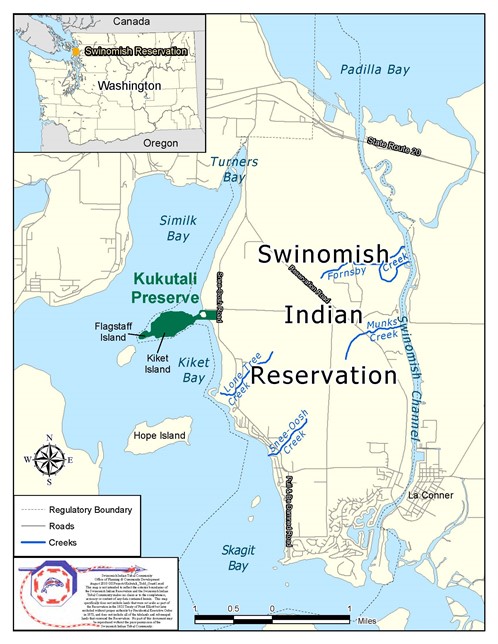
Kiket Island is within the Swinomish Indian Reservation, but was transferred into private ownership in the early twentieth century. In 2010, several state and federal grants, Tribal funds, and private donations allowed the property to be purchased as a Preserve to protect its special environments, and to allow everyone to experience this special place.
Historic use of the area by the Tribe included shellfish gathering and beach seining for salmon. The traditional name of the area Kukutali means “place of cattail mat” referring to the temporary shelters erected of cattail mats at the summer clam digging and beach seining sites.
Trail Map & Descriptions
We ask that you respect the natural environment by staying on the designated trails.The beaches and tidelands, which are owned exclusively by the Swinomish Indian Tribal Community and are not part of the Preserve, are open for walking where indicated but not for harvesting of any kind (see Trail Map below and note seasonal beach closures).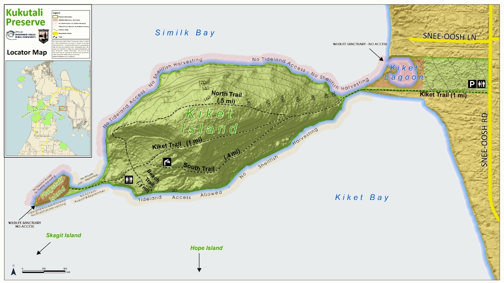
Center trail: a gravel roadway across the island, the center trail has moderate elevation gain and loss, and is the most direct route to the west end of the island.
North trail: a peaceful forest trail through old growth, the North trail gains the most elevation, takes a little longer to walk, and offers interesting views at the west end.
South trail: the easiest of the trails, the south trail avoids most of the elevation gain as it wanders through broad leafed trees along the south side.
There are restrooms and a picnic shelter available in the meadow at the west end of Kiket island.
The property south of the road leading to Kiket Island is private. Please respect this private property.Emergencies of any kind
Call 911. A Park ranger or tribal police officers will respond.